

Returning Winter Recreation to Mt. Pilchuck
- Kira Tully

- Apr 6
- 8 min read
Updated: Jun 6

Cascade Backcountry Alliance is exploring the feasibility of returning winter recreation to Mt. Pilchuck through the establishment of a Washington State Parks Sno-Park at the present-day summer trailhead.
We believe that Pilchuck, which had a ski area from 1956 to 1979, has the potential to create a new high-elevation snow access point serving Snohomish County for backcountry skiing, snowshoeing, snow play, and sledding.
Washington State Parks manages over 100 locations around the state for winter recreation access through the Sno-Parks program. Sno-Parks are served by road plowing, parking lots, and, in some cases, cross-country ski trail grooming. The program is entirely funded by Sno-Park pass sales.
Pilchuck has numerous qualities that we believe make it an excellent candidate for a future Sno-Park. Including it in the Sno-Park program provides the requisite funding to reestablish winter access and allow for a wide variety of winter uses.
Potential Uses
A Pilchuck Sno-Park would cater to multiple user groups. Specifically, we envision the following uses:
Ski touring: We like Pilchuck primarily because of its high elevation of 5,344ft (between the summits of the Stevens Pass and Mt. Baker ski areas) and its access to excellent skiing terrain.
Snowshoeing: The existing summer hiking trail also lends itself well to snowshoers gaining the summit. This route provides an avalanche-safe route to the summit and with views towards the Cascades to the east and Puget Sound to the west.
Sledding and snow play: The large parking lot and gentle slopes nearby offer sledding and space for snow play for families with small children.
As it stands, nearly all high elevation winter-time snow access points in Western Washington that provide these activities are adjacent to commercial ski areas. These ski areas suffer from massive overcrowding problems and lack of parking. In recent years they have taken steps to restrict parking access for non-patrons thereby further restricting snow access for Western Washington residents.
A Sno-Park at Mt. Pilchuck would create an additional easily accessible snow access point free of ski area control.
Why Pilchuck?
Why, then, is Pilchuck the right location for this? From 1956 until 1978 a lift-served ski area existed at Mt. Pilchuck. The infrastructure it left behind (road and large parking lot) is a primary reason Cascade Backcountry Alliance is evaluating it for proposal as a future Washington State Parks Sno-Park.
Specifically, its road access and parking lot lend themselves exceptionally well to becoming a Sno-Park. What’s more, Pilchuck’s location is in an area in Snohomish county that is otherwise underserved by the Sno-Park program.
Terrain & Elevation
Pilchuck tops out at 5,344ft. While this isn't anything exceptionally high for the Cascades, it is at a good elevation for skiing and is between the summit elevations of the Mt. Baker and Stevens Pass ski areas. The terrain is well suited to skiing as well (evidenced by its former status as a ski area).
While the lower sections of the mountain, formerly cleared as ski runs, have filled back in with foliage in the decades since the closure, the upper mountain remains excellent ski terrain. On the north aspect (pictured below), there is a plethora of moderately sloped terrain from the summit towards the trailhead to the west or Larrison Ridge to the east. From the summit itself is the Gunsight Couloir (featured in the photo at the top of this article), a 40° slope just to the east of the fire lookout. From the bottom of the couloir, the moderately sloped and gladed south face of the mountain can be skied lower down as well.

Regarding climate change, anything over 4,000ft is likely to remain decent skiing for the foreseeable future. Plowing an existing road for winter recreation doesn't require a long-term capital investment and would provide access to ample snow in most years.
Parking Lot
Another way in which Pilchuck benefits from its former status as a ski area is its parking lot. Unlike many hiking trailheads, which have limited parking available, the Pilchuck trailhead is exceptionally large due to it being originally built for the former ski area. This would translate to a parking lot with a capacity of over 100 cars for a future Sno-Park.
Location
Located on the far western edge of the Cascades, Pilchuck is more easily accessible to North Seattle and Snohomish County residents than many other areas located deeper in the Cascades. The amount of traffic in the area during the winter is minimal since it sits along Mountain Loop Highway. In comparison, the traffic on US-2 through Sultan can add an hour or more to trips back to Seattle. Expanding winter access along Mountain Loop Highway makes use of an underutilized area of the Cascades in the winter and brings additional economic activity to Granite Falls.
The other benefit Pilchuck's location provides is increasing access in an area currently underserved by the Sno-Park program. There are currently few Sno-Parks that are of use to Snohomish County residents. The addition of a Sno-Park in this location has the potential to drive many new pass sales, helping the Pilchuck Sno-Park pay for itself and, perhaps, to become a net-positive revenue generator for the entire Sno-Park program.

Road Access
The Pilchuck road itself is currently gated at the Heather Lake trailhead during the winters. The road beyond the gate extends 5.5 miles to the Pilchuck trailhead.
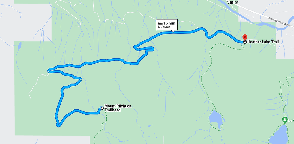
This is the segment that would require plowing. 5.5 miles is a considerable amount of road to plow, but there are three factors that make this easier.
The elevation of the road transitions from ~1,300ft at the Heather Lake trailhead to ~3,100ft at the Pilchuck trailhead. Only a portion of this road receives consistent snow throughout the winter meaning not all of it would require plowing.
Uniquely, the top portion of the Pilchuck road remains paved from its days as a ski area. This makes plowing easier and alleviates concerns around additional wear put on the road by winter traffic.
The road weaves its way through the forest and does not cross any areas of significant avalanche danger. This means no expensive avalanche control is required.
While plowing a road of this length is not cheap, creating an entirely new high elevation winter snow access point for the cost of plowing only five miles of road is a significant return on investment. It’s also not without precedent – the Marble Mountain Sno-Park has a plowed road of comparable length.
Diverse Recreation
Finally, another strength Pilchuck offers is the wide variety of winter recreation possible. Many existing Sno-Parks cater to cross-country skiing, snowshoeing, and snowmobiling, but few offer ski touring from high elevation trailheads.
Pilchuck’s location, terrain, and elevation make it an attractive option for ski touring in addition to the other types of winter recreation Sno-Parks typically cater to. This directly helps achieve the Sno-Park program’s goal of providing diverse winter recreation options per its strategic plan:
"The Winter Recreation Program is a well-managed and respected program of the Washington State Parks and Recreation Commission providing effective and efficient service that: [...] facilitates public access to diverse snow-based recreational opportunities."
How Do We Make This Happen?
Cascade Backcountry Alliance has spent the past year researching the feasibility of establishing a Sno-Park at Mt. Pilchuck. This has involved considerable background research and discussions with land managers and stakeholders.
Conversations are ongoing, but eventually we hope to bring Pilchuck to the Washington State Parks Winter Recreation Advisory Committee for formal consideration as a Sno-Park.
The WRAC is a volunteer-based board of community members that works with Washington State Parks staff to review proposals for new Sno-Parks and determine which are funded.
An organization proposing a new Sno-Park must go through the following steps:
Get approval from the land manager where the Sno-Park is proposed (USFS in this case).
Submit an initial proposal, including an estimated budget for plowing and restroom maintenance, to the WRAC and the land manager.
Receive budget approval by a WRAC vote. If approved, the Sno-Park goes through a 3-year pilot program, requiring WRAC approval for additional funding each year until made permanent.
To get to that point, we need continued community engagement and support of CBA's access initiatives. If you support this type of continued winter recreation access, please consider some of the following:
Reach out to us if you or a local community group you are part of is interested in supporting this project- email project leads Kira and Kyle.
Join our e-mail list and follow us on social media to get updates on Pilchuck and opportunities to get involved.
Donate to CBA to propel our mission.
Buy a Sno-Park pass! There is tons of great skiing and snowshoeing from our various Sno-Parks, and having a robust budget each year allows new Sno-Parks to be funded.
Tell a friend about why Mt. Pilchuck would be a great Sno-Park and help us spread this idea across the outdoor community!
FAQ
Who will fund and manage road plowing and winter maintenance?
Under our proposal, the Washington State Sno-Park program would fund road plowing and winter maintenance. The program is 100% funded by user fees, meaning it is self-sustaining and not dependent on other funding sources. The plowing would be conducted by a local contractor or non profit. CBA is currently trying to identify potential plow operators.
How will safety and search & rescue be managed?
Safety is a top priority of Cascade Backcountry Alliance. There will be recreation opportunities, such as snow play, close to the trailhead where risks from avalanche and cold weather are lower. Providing visitors with clear information and well-defined recreation opportunities can help reduce the likelihood of people becoming lost, entering hazardous terrain unintentionally, or being unprepared for winter conditions. As with all winter recreation areas, visitors remain responsible for assessing conditions, carrying appropriate equipment, and making decisions consistent with their experience and skill level. Opportunities for intermediate and advanced winter snowshoe and ski routes are available, and CBA is committed to working with land managers to ensure proper signage and educational materials are available.
How will avalanche safety be addressed at the proposed Sno-Park?
We anticipate this will be addressed similarly to other Sno parks with information on the Sno park website and at the trailhead that directs users to the NWAC forecast. Similar to Franklin Falls, we also anticipate designing more detailed maps that outline areas with avalanche risk. View example map.
Will snowmobiles and motorized vehicles be allowed?
At this point, we are anticipating this to be a non motorized recreation spot. However, if you are from the motorized community and want to discuss collaboration opportunities, please reach out to CBA.
What will this cost visitors, and will it remain publicly accessible?
A daily Sno-Park pass costs $25 per vehicle, while an annual non motorized pass costs $50 per vehicle. These fees support the plowing, staffing, and winter maintenance to open these locations. Currently, the gate is closed in the winter 5 miles before the summer trailhead. The Sno-Park would be accessible to any member of the public who buys a pass.
How will environmental and ecological impacts be addressed?
CBA will work with land managers, including tribes, to ensure that serious environmental impacts will be considered. By providing a dedicated spot for winter recreation, the Pilchuck Sno-Park would concentrate the environmental impacts of winter recreation. Additionally, education from rangers and signage could help mitigate the impact of the public.
What happens if there isn’t enough snow?
Like all winter recreation areas in Washington, the proposed Pilchuck Sno-Park would be subject to seasonal weather and snow conditions. Snow levels can vary significantly from year to year and throughout the winter season, and this variability is not unique to Pilchuck. Existing Sno-Parks across the state regularly experience periods of limited snow coverage, delayed snow accumulation, or temporary closures due to changing conditions.
Although there are no snowfall measurements on Mt. Pilchuck, a nearby Snotel site at a slightly higher 3500 ft in elevation typically reaches a maximum snowpack of 58 inches of snow water equivalent, which translates to about 10 feet of snowpack using a conservative estimate of 2 inches of snow for every one inch of water in a consolidated snowpack. While the Pilchuck Sno-Park would be slightly lower than this, there are many recreation opportunities above this elevation, where an even deeper snowpack would be expected.
If there is not enough snow to support winter recreation activities, some uses may be limited or unavailable until conditions improve. Visitors would be encouraged to check current weather, road, and snow conditions before traveling and to be prepared for changing mountain weather.

Comments